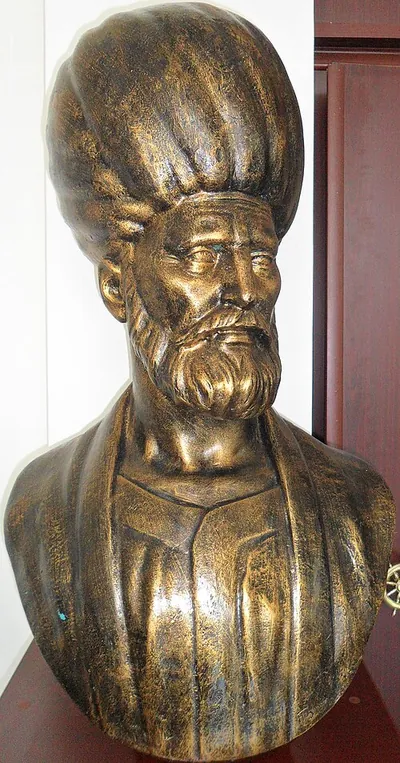
Piri Reis
Ottoman admiral, navigator and cartographer, author of the 1513 world map and the nautical atlas Kitab-ı Bahriye · 1470–1553
- Born
- 1470
- Died
- 1553
- Country
- Ottoman Empire
- Section
- Transport
Biography
Piri Reis was an Ottoman admiral, navigator, corsair and cartographer, best known for the world map he drew in 1513 and for the Kitab-ı Bahriye (Book of the Sea), a nautical atlas with charts of harbours and coasts across the Mediterranean. He lived in a period of great change: Europeans were exploring the Atlantic and the Americas, while the Ottoman Empire was establishing itself as the dominant power in the eastern Mediterranean. His work matters because it shows how the world looked from Istanbul during the Age of Discovery, and because his career combined piracy, naval warfare and the making of maps.
He later described himself as Muhiddin Piri, son of Hacı Mehmed. He was probably born in Gelibolu (Gallipoli), in present-day Turkey, sometime between 1465 and 1470, since no exact date survives. Gelibolu was a major Ottoman naval base, and the historian Ibn Kemal wrote that its children were rocked to sleep by the sound of the sea and the ships. His parents probably died around 1481, according to scholars, and after that he worked aboard the ship of his uncle Kemal Reis, a well-known corsair who operated in the Mediterranean with a loose licence from the state. Piri later recalled an episode from those early years. Soon after he began sailing with his uncle, a storm nearly wrecked their galley in a small rocky harbour near Mount Athos, and Orthodox monks came down to the water and tied the ship down with ropes until the weather calmed. Besides his native language, he spoke Arabic, Greek, Spanish and Portuguese, which was unusual among sailors of his time.
He took part in many corsair raids with his uncle. Under Sultan Bayezid II he sailed west to support the Emirate of Granada, the last Muslim-ruled territory in Iberia, and in 1487 he helped bombard the forces besieging Málaga, which fell before the end of that year. Piri and Kemal described themselves as sea gazis, a term for holy warriors of the sea. Corsairs differed from ordinary pirates because they worked under a degree of state permission, and from privateers in wartime because their activity had no fixed end. For six years they raided the coasts of Spain and France and the islands of Corsica, Sardinia, Sicily and the Balearics. Piri noted everyday details there, such as the ships loading salt at Ibiza or the spring in Menorca hidden behind a large mountain. After Spain expelled its Jews in 1492, Bayezid II asked Kemal to help the refugees, and Piri carried Muslims and Jews from Spain to North Africa.
In the wars between the Ottoman Empire and Venice, Piri commanded his own galley under his uncle. A galley was a shallow warship driven by oars, well suited to Mediterranean coasts. In 1499, during the battle of Zonchio, he steered one of the ships that broke through the much larger Venetian fleet and entered the Gulf of Corinth, which led the Venetian governor to surrender. In 1501 he returned to attack the Spanish coast with Kemal, and they captured a man who claimed to have sailed with Columbus and who probably carried charts of the Americas. Kemal drowned around 1511, when his ship sank in a storm near the island of Samos. Piri remembered him with a eulogy included in the Kitab-ı Bahriye.
After his uncle's death Piri returned to Gelibolu and turned his attention to cartography. There he completed the world map of 1513, dated to March of that year in the Islamic calendar, which showed the recently explored coasts of America and Africa. During the Ottoman conquest of Egypt (1516–1517) he led the ships that blockaded Alexandria, and after the victory he presented the map to Sultan Selim I. How the sultan used it is unknown, and the document vanished from history until its rediscovery. The map also referred to a lost chart by Christopher Columbus, a detail that drew attention centuries later. His atlases grew over time. The first version of the Kitab-ı Bahriye, from 1521, was offered to Suleiman the Magnificent and included advice on conquering Rhodes, an effort in which Piri took part during the siege of 1522. The second version, from 1526, grew out of a conversation with the grand vizier Pargalı Ibrahim Pasha, who asked about the maps used aboard ship, and it became the fullest atlas of his career.
Piri's life was marked by tension. In 1518 he joined a revolt of captains against the sultan, which was brief; he was back in Ottoman service before the conquest of Rhodes, and the reasons for his defection remain unknown. Between 1528 and 1547 he almost disappears from Ottoman records, although Venetian sources keep tracking him as a constant threat. In 1532 he attacked pirates in the Adriatic and joined the siege of Coron, and in 1536 he seized the galley Contarina near Cyprus and refused to return its cargo of precious stones, claiming it had carried Muslim prisoners. In 1546 he attacked the Venetian ship Liona, killing and wounding several sailors, though the grand vizier Rüstem Pasha sided with him in the diplomatic dispute that followed.
In 1547 he was named grand admiral of the Ottoman fleet in the Indian Ocean, based at Suez. There the Ottoman navy faced the Portuguese, whose sailing ships could cross open ocean, while the Ottomans relied largely on galleys, which were better near the coast. In 1548 he took the citadel of Aden, and in 1549 he pursued a Portuguese squadron that tried to flee and destroyed it. He was rewarded with a grant of land revenues, but his final assignment proved fatal. In 1552 the sultan ordered him to take Hormuz, a Portuguese possession since 1515. Piri seized Muscat and entered the city of Hormuz, but could not capture the fortress. After weeks of siege, a shortage of gunpowder forced him to lift it on 9 October 1552, after he had looted the city and the island of Qeshm. He returned to Basra with only two ships, since the rest of the fleet had been left behind, and there the governor Kubad Pasha refused to supply rowers. Back in Egypt, he was accused of having abandoned the siege for a bribe. Historians consider the charge unlikely, but the sultan believed it and ordered his execution in Cairo in late 1553.
Piri Reis's legacy is twofold. As a cartographer he left two major works that shaped Ottoman navigation, and his 1513 world map, lost for centuries, became a national symbol in Turkey, to the point of appearing on the back of banknotes worth ten million lira. When it was rediscovered in 1929 during renovations at the Topkapı Palace, some writers claimed without evidence that it showed Antarctica free of ice, a theory later studies have not supported. He has also entered popular culture, appearing as a character in the video game Assassin's Creed: Revelations and in Age of Empires III.
Main contributions
- 1513A world map showing the recently explored coasts of America and Africa, which cites a lost chart by Columbus.
- 1521First version of the Kitab-ı Bahriye, a nautical atlas with charts of Mediterranean harbours and advice on taking Rhodes.
- 1526Expanded second version of the Kitab-ı Bahriye, dedicated to Suleiman, which became his fullest atlas.
- 1528Map of the American coasts based on Portuguese charts, in which Florida appears and Cuba is drawn as an island.
Trivia and anecdotes
A map on banknotes
His world map appeared on the back of old Turkish banknotes worth ten million lira, making it a national emblem.
An ice-free Antarctica
After its rediscovery in 1929 some claimed the map showed an Antarctica without ice, an idea that studies have not confirmed.
Monks with ropes
According to his own account, Orthodox monks tied his uncle's galley down with ropes during a storm near Mount Athos.
Their contemporaries
While Piri Reis was alive (1470–1553)…
Alive at the same time
Discovered or invented in those years
- 1494Double-entry bookkeepingAn accounting method in which every transaction is recorded twice, as a debit and a credit of equal amount, so that the books always balance.
- 1495Leonardo's robotA humanoid automaton shaped like a medieval knight, designed and possibly built by Leonardo da Vinci around 1495, moved by pulleys and cables.
- 1500Magnetic declinationThe angle between the magnetic north shown by a compass and true north, which varies from place to place and changes over time.
- 1500RiflingSpiral grooves cut inside a firearm's barrel that spin the projectile to stabilise its flight and improve accuracy.
- 1543HeliocentrismAn astronomical model that places the Sun, rather than the Earth, at the centre of the system in which the planets orbit.
- 1545Vieta's formulasFormulas linking the coefficients of a polynomial to the sums and products of its roots, without having to compute the roots themselves.
 Nicolas-Joseph Cugnot1725–1804 · Transport
 Robert Fulton1765–1815 · Transport
 Richard Trevithick1771–1833 · Transport
 George Cayley1773–1857 · Transport
 George Stephenson1781–1848 · Transport
 Karl Drais1785–1851 · Transport
